🧭 The Ultimate Guide to Navigation: Why Every Camper Should Master the Compass
Because batteries die, screens crack, and satellites fail — but the compass never lies.
Introduction: The Illusion of Easy Navigation
Modern explorers have never had more tools at their fingertips. A single smartphone can display topographic maps, GPS coordinates, elevation data, and even satellite images of remote trails. Handheld GPS units can pinpoint your location within a few feet and track your route back to camp. These are incredible innovations — and when they work, they feel almost magical.
But every experienced outdoorsman knows that technology has limits. Batteries drain faster in the cold. Screens are hard to read under bright sunlight. A single drop in the creek or fall on a rocky trail can turn your expensive GPS device into a paperweight. Even satellite coverage can fade when valleys narrow or storms roll in.
When that happens, the only thing you can truly rely on is skill — and a small, silent instrument that has guided explorers for centuries: the compass.
A compass never runs out of power. It doesn’t require Wi-Fi or updates. It points north — always. And once you know how to read it, it can lead you anywhere on Earth.
At River Mountain Gear, we believe that mastering navigation isn’t just about safety — it’s about freedom. Whether you’re hiking for a day or crossing backcountry terrain for a week, this guide will teach you how to make the compass your most trusted companion.
Part 1: Understanding the Compass — A Tool Older Than Maps
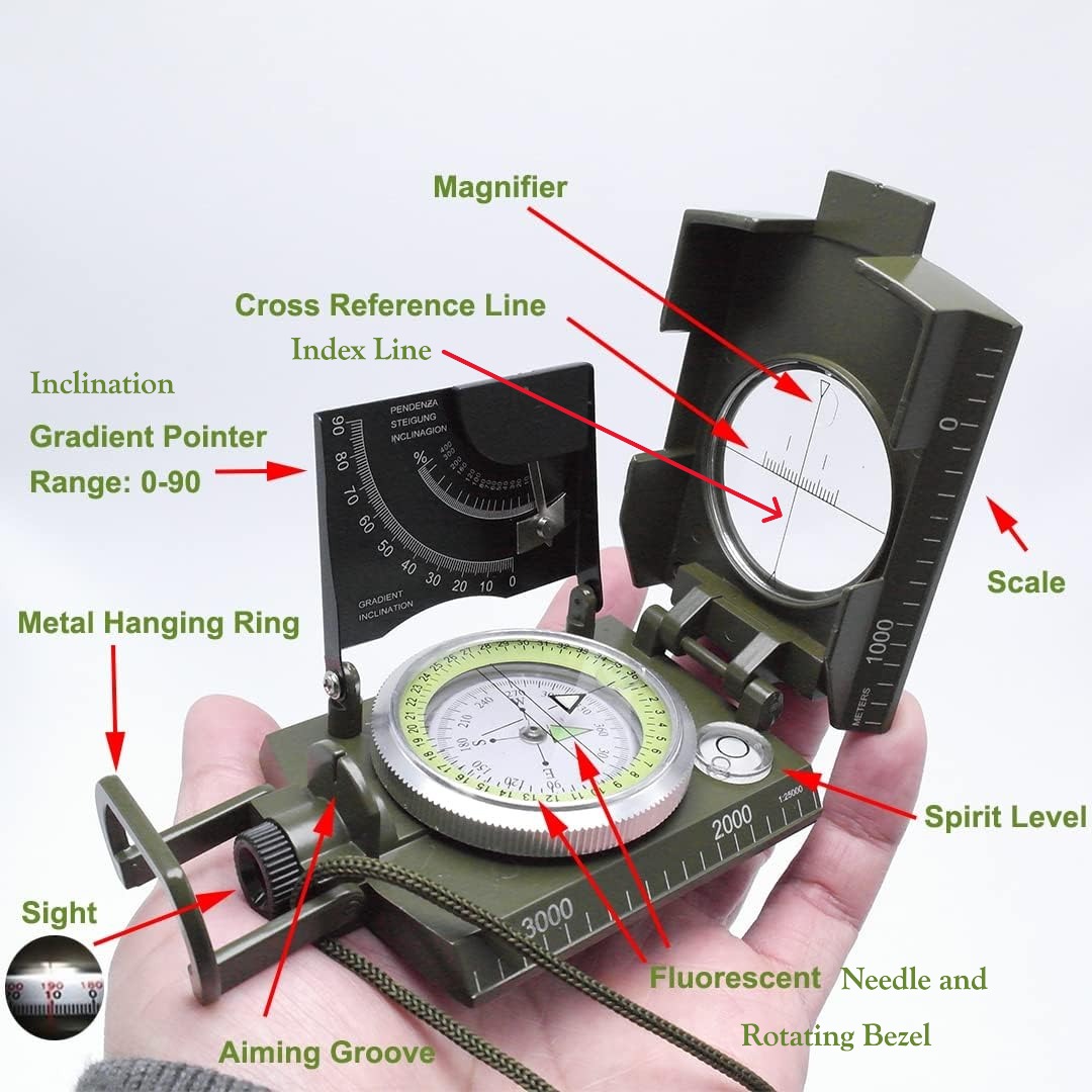
The Anatomy of a Compass
At first glance, a compass looks simple: a floating needle inside a round housing. But each part is designed with precision to help you find your way.
-
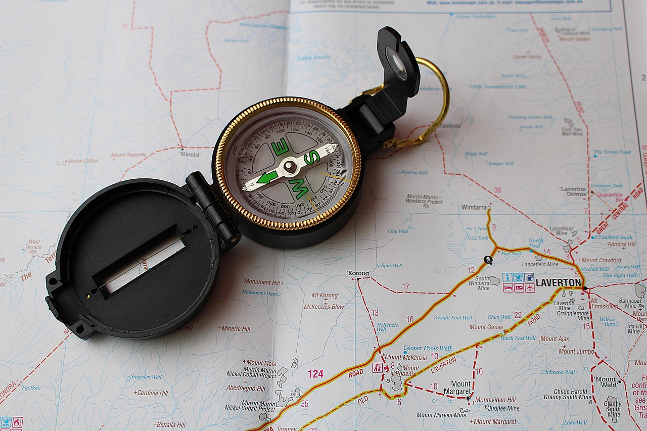
Baseplate: The flat, transparent foundation of the compass. It allows you to see the map beneath it and align edges with landmarks or map features. (not used on lensatic compass)
-
Rotating Bezel (Compass Dial): The numbered ring that rotates around the needle housing. It’s marked from 0° to 360°, representing every possible direction on Earth.
-
Magnetic Needle: A slender, balanced pointer that always aligns with the Earth’s magnetic field. The red or florescent end points to magnetic north.
-
Orienting Arrow: A red or florescent outline inside the bezel that helps you align the needle with north when taking or following a bearing.
-
Direction-of-Travel Arrow: A bold arrow printed on the baseplate that shows which way to walk once your bearing is set.
-
Sighting Mirror or Hole: Found on advanced models, this feature lets you take more precise bearings by sighting distant objects.
-
Declination Adjustment Screw: Allows you to set your compass to compensate for the difference between true north and magnetic north.
- Inclination: The angle between earth’s magnetic field and the earth’s horizontal surface.
Together, these components turn raw magnetism into directional intelligence. When you hold one, you’re holding hundreds of years of navigational evolution.
Part 2: Setting Orientation — Making Your Map and Compass Agree
A compass alone points north, but a map alone shows detail. Combine the two, and you gain total spatial awareness.
To orient your map:
-
Lay it flat on the ground.
-
Place your compass along the map’s north-south grid lines.
-
Rotate the map and compass together until the magnetic needle lines up with the orienting arrow.
Now your map is aligned with the actual world. The top of the map points north, the bottom south, left is west, and right is east. Every hill, stream, and road lies in its true direction relative to where you’re standing.
This step may sound small, but it’s one of the most powerful actions in navigation. A properly oriented map turns abstract symbols into a living, breathing landscape.
Part 3: Bearings — The Language of Direction
A bearing is simply a numerical expression of direction. North is 0° (or 360°), east is 90°, south is 180°, and west is 270°. Everything else falls in between.
Let’s say you’re standing at camp and want to hike toward a distant lake.
-
Lay your compass edge between your location and the lake on your map.
-
Rotate the bezel until the orienting lines inside the compass housing line up with the map’s north-south lines.
-
Read the number at the top of your direction-of-travel arrow — that’s your bearing.
-
Now, hold the compass flat, turn your body until the red or florescent needle fits inside the orienting arrow, and walk forward.
You’re now traveling in a straight line toward your lake, guided purely by magnetic precision.
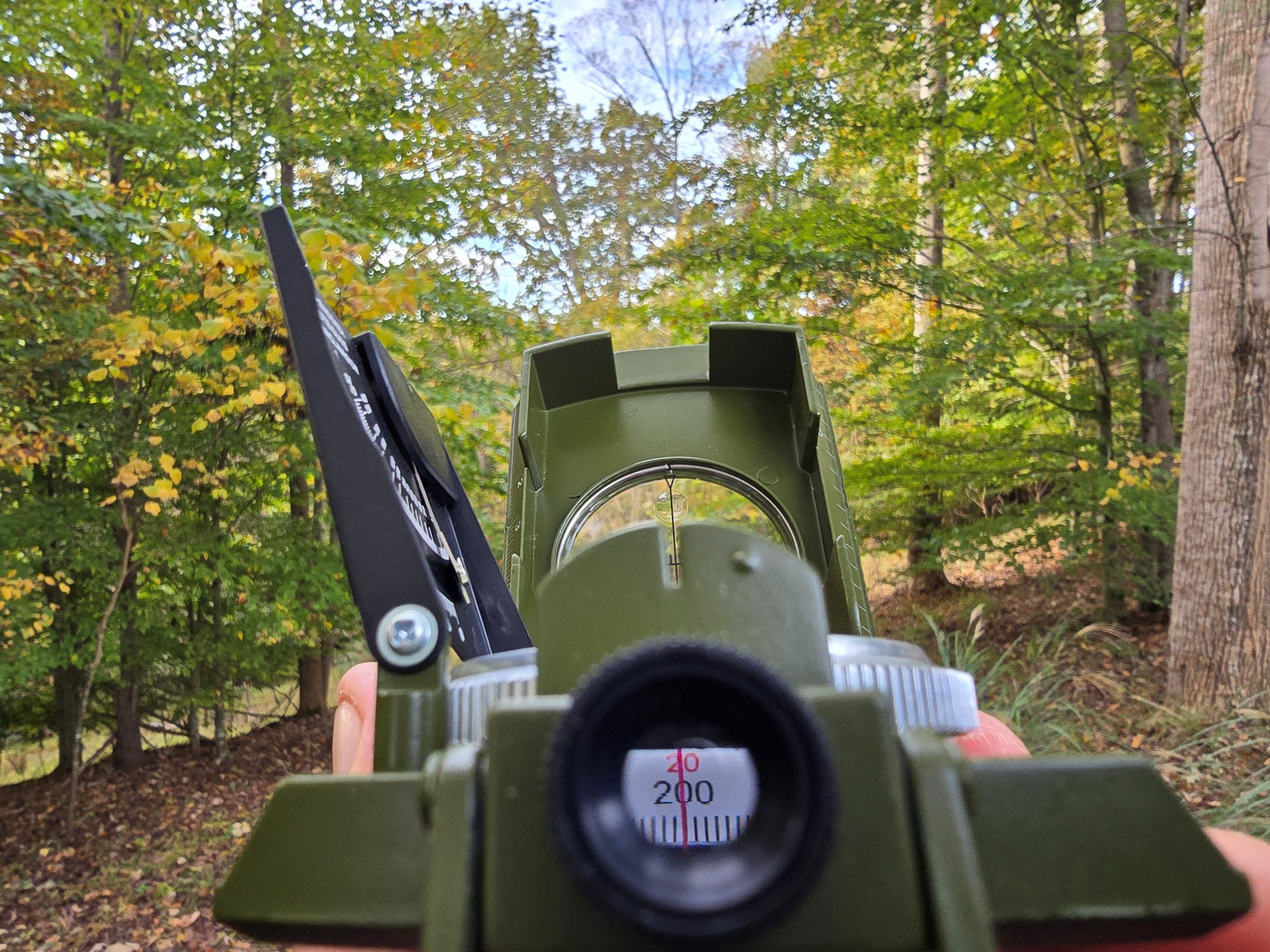
Part 4: The Sight Hole — Precision Over Distance
On long routes or across open terrain, even a small error can send you far off course. That’s where the sight hole or sighting mirror comes in.
By holding the compass level at eye height and looking through the sight toward a distant object, you can line up your bearing with pinpoint accuracy. This reduces parallax error (the small shifts that happen when you move your head) and keeps your navigation true even across miles of uneven ground.
Professional navigators often sight one bearing, walk toward a mid-distance landmark (like a boulder or tree), and then re-sight another — maintaining an invisible line through the wilderness.
Part 5: Declination and Inclination — The Hidden Forces
Most people are surprised to learn that true north and magnetic north aren’t the same. The difference between them — called declination — varies depending on where you are on Earth.
In Virginia, for instance, declination is roughly 8° west, while in Colorado it can exceed 12° east.
If your compass doesn’t have an adjustment screw, you’ll need to add or subtract that offset manually whenever you plot or follow bearings.
Ignoring declination can slowly pull you off course — by hundreds of feet or even miles.
Inclination, on the other hand, refers to the vertical dip of Earth’s magnetic field. Compasses are balanced differently in each hemisphere to account for this, so if you travel internationally, look for a global needle compass that functions accurately anywhere.
Part 6: Reading the Land — Terrain Association
Even with a compass, your greatest navigational asset is your awareness. Look for natural indicators — the slope of the ground, the direction of rivers, the type of vegetation. These features help confirm your position and bearing in real time.
When your compass points north and your eyes confirm the shape of the land, you’re not just navigating — you’re interpreting the wilderness.
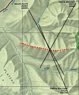
Part 7: Triangulation — Pinpointing Your Location
Triangulation is one of the most satisfying techniques in navigation because it combines geometry and observation.
1. Choose two visible landmarks (mountains, towers, lakes).
2. Take a bearing to each using your compass.
3. Plot those bearings on your map by aligning the compass edge and drawing a line along the direction of travel.
4. The point where the lines intersect — that’s where you are.
Add a third landmark, and your accuracy becomes even sharper. This method can pinpoint your location within a few dozen feet — no satellites required.
Part 8: Practical Field Drills
1. The Straight-Line Challenge
Walk a 200-yard course on a set bearing. Stop and check how close you are to your intended mark. Repeat until your drift is less than 5°.
2. The Leapfrog Technique
When visibility is low, pick a close object in your bearing line — a stump, boulder, or tree — and walk to it. Then select the next. This maintains your course even in dense forest or fog.
3. Triangulation Practice
At home, use a local map and identify landmarks you can see from your position. Plot their bearings and check your accuracy.
4. Night Navigation
Practice following bearings under low light with a headlamp. Use glow markings or tritium compasses to stay oriented.
Part 9: Why Every Camper Should Own a Compass
A compass weighs less than an ounce but can save your life. It teaches patience, confidence, and independence. It turns fear of getting lost into the joy of exploration.
At River Mountain Gear, we carry durable, field-tested compasses and navigation tools that belong in every pack — whether you’re on a day hike, a hunting trip, or a week-long mountain trek.
Your GPS may fail. Your phone may die. But your compass — your most ancient, reliable ally — will always be there to guide you home.
![]()